Workshop on Multi-hazard Mapping in Yolanda Affected Areas

Typhoon Glenda updates Infographic
November 29, 2016
Initiating and Sustaining Action: Experiences Building Resilience to Climate Change in Asian Cities.
November 30, 2016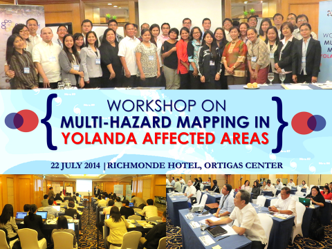
by: Charlene Mae Arkaina
The OML Center in partnership with the Department of Science and Technology (DOST) and the Disaster Risk and Exposure Assessment for Mitigation (DREAM)-Light Detection and Ranging (LIDAR) project organized the Workshop on Multi-hazard Mapping in Yolanda Affected Areas, held July 22, 2014 at Richmonde Hotel, Ortigas Center.
The workshop, which brought together around 40 participants from various organizations, served as a venue of communication relating to the use and need for hazard and other scientific information developed and harmonized by the DREAM-LiDAR Program through the Yolanda Rehabilitation Scientific Information (YoRInfo) Center.
The YoRInfo Center is a science-based data and information center which serves as a one-stop center to assist in rehabilitation efforts in Yolanda-affected areas by providing available scientific information such as topographic maps, multi-hazard maps from Mines and Geosciences Bureau (MGB) and DOST, and latest satellite images of Yolanda-affected areas.
The workshop was divided into two sessions; the first one entitled YorInfo Center: Data Availability, Access and Sharing were discussed by Engr. Sarah Jane D. Samalburo, the Chief Science Research Specialist for Data Processing Component of the DREAM Program. The second session on the other hand was the Panel Discussion on Data Availability and Needs for Hazard and Risk Information for Yolanda-related efforts. The discussants were Atty. Linda Hornilla, the Commissioner of Housing and Land Use Regulatory Board (HLURB) for Housing and Settlements; Ms. Ma. Angela Mamuyac, the Local Government Operations Officer and Section Chief of the Local Development Planning Division of the Department of Interior and Local Government (LDPD-BLGD, DILG) for Disaster Preparedness for Local Government Units; and Ms. Ma. Christine Reyes, Grants Program Director of Philippine Disaster Recovery Foundation (PDRF) for Environment and Livelihood (Housing and Settlement Clusters). The participants were given time to provide reactions to the presentations, need or scientific information and suggestions/recommendations on Data Sharing, Access and Use.
Assistant Secretary Raymund Liboro of DOST delivered the keynote speech discussing the available science-based information developed and facilitated by DOST and the DREAM Program and its policy on data sharing for the rehabilitation of areas devastated by typhoon Yolanda and Mr. Arturo Valdez, Member of the OML Center Board of Trustees gave the closing message, and Engr. Glenn Banaguas of De La Salle Arameta University was the Master of Ceremony.
The output of this workshop will be presented on the “Workshop on Translating Climate and Disaster Information for Effective Decision-Making” to be held August 7, 2014 at Richmonde Hotel, Ortigas Center.
You can view the photos from the workshop here.
A conference proceeding will be published on this site soon. Please visit this website for more updates on this event and in other upcoming events, or email info@omlopezcenter.org.