Poster: Mapping Social Vulnerability in Haiyan-affected Areas

Call for Applications: CSAG PhD Funding Opportunity
December 11, 2016
OML Center at the Resilient Cities 2015: 6th Global Forum on Urban Resilience and Adaptation
December 11, 2016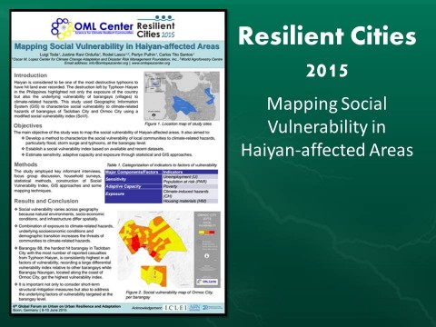
The OML Center has released a poster on Mapping Social Vulnerability in Haiyan-affected Areas that exhibits a study that uses Geographic Information System (GIS) to characterize social vulnerability to climate-related hazards of barangays of Tacloban City and Ormoc City using a modified social vulnerability index (SoVI).
Results have shown that social vulnerability varies across geography and that the combination of exposure to certain social and environmental factors increase community vulnerability. In addition, it was concluded that underlying factors of vulnerability targeted at the barangay level should be addressed along with short-term structural mitigation.
Click here to access the file.
Tags: