OML Center’s Project helped farmers of Apalit, Pampanga adapt to flooding through zone maps

Oscar M. Lopez Center Weather Advisory, 23 Nov. 2015, 0830H
December 11, 2016
Oscar M. Lopez Center WEATHER ADVISORY, 24 November 2015, 7:30 AM
December 11, 2016OML Center’s Project helped farmers of Apalit, Pampanga adapt to flooding through zone maps
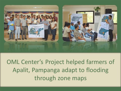
By John Colin Yokingco and Perlyn Pulhin
“I was enlightened, thank you,” shared by one of the farmer leaders in the municipality of Apalit, Pampanga who attended the validation workshop organized by the Oscar M. Lopez Center for Climate Change Adaptation and Disaster Risk Management Foundation, Inc (Oscar M. Lopez Center) last September 24, 2015. This is part of the culmination stage of the project on Flood Inundation Mapping Using Light Detection and Ranging (LiDAR) and Geographic Information System (GIS): Mapping Appropriate Cultivation Areas in Apalit, Pampanga (FIMULG), one of the Center’s banner projects. The project sought to aid farmers in adapting to the negative effects of floods through the use of state-of-the-art technologies such as LiDAR and GIS.
The results of the two year study were presented by the Center’s Research Team to the municipal agricultural office and the farmer leaders of the municipality of Apalit. Maps showing four zones that highlighted cropping areas that will be most affected by the depth and duration of floods during an event were shown to the participants. These maps were able to display areas that would be at risk and so farmers can plan their adaptation strategies.
A representative from the International Rice Research Institute (IRRI) who was invited at the workshop was able to supplement the FIMULG maps by providing seedlings of flood-tolerant rice varieties to the municipal agricultural office. The Center also gained valuable feedback regarding the results of the project such as the validity of the maps as well as the possible ways of improving the suggested strategies.
While the original intention is to impart scientific knowledge to the farmers of Apalit, the Center was also able to learn from them particularly on incorporating the farmer’s feedback in improving the presentation of the maps. The Research Team succeeded in displaying the use of high-tech solutions such as LiDAR and also realized that the participation of the community is valuable for these solutions to work. The lessons learnt from the presentation as well as the project as a whole are hoped to be used to improve future projects.
Publications featuring the project:
Poster presented in 4th National Climate Conference
Poster presented in Regional Forum on Climate Change
Infographic on Climate Smart Agriculture in the Philippine Context
Poster presented in Intergovernmental Panel on Climate Change Expert’s Meeting