Empowering Local Governments for Climate Change Resilience through GIS Training

Designing a climate resilient future: A guide to integrating multiple perspectives in spatial planning
December 8, 2016
Interdisciplinary Studies Center on Food Security Kicks off Round Table Discussion Series
December 8, 2016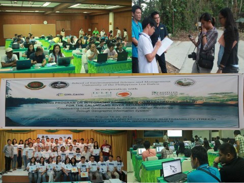
By: Justine Ravi C. Orduna
The Training Program on Integrated River Basin Co-management (IRBCM) for the Calumpang River Rehabilitation: Empowering Local Governments for Climate Change Resilience through Geographic Information System of the University of the Philippines Los Banos (UPLB), School of Environmental Science and Management (SESAM) was successfully held on August 18-20 2014 at the Training Center for Tropical Resources and Ecosystems Sustainability (TREES), UP Los Banos. This event was co-organized by the OML Center and ICLEI-Local Governments for Sustainability Southeast Asia Secretariat (ICLEI SEAS) and in partnership with the Local Government of Batangas City.
A total of 36 participants from six Local Government Units (LGUs) in Batangas Province comprising the Calumpang River Basin (Batangas City, Taysan, San Jose, Lipa, Padre Garcia, Rosario) and nine LGUs under the ICLEI-ACCRN Project (Baguio City, Bacnotan, San Fernando, Tublay, Makati City, Marikina City, Quezon City, Naga City, Catbalogan City) were taught how to mainstream climate change adaptation (CCA) and disaster risk reduction and management (DRRM) to local governments planning and operations using Geographic Information System (GIS). The training also aimed to enhance geospatial capacities of constituents of the LGUs in support ofthe long-term vision of a more holistic approach to CCA and DRRM.
The resource person for the first day was For. Ozzy Boy Nicopior from Phil-LiDAR 2. He gave an introduction to GIS (Concepts, history, applications, data structures, running a GIS Software QGIS ver2.2) and facilitated GPS reading and geo-tagging activities. For. Nicopior is an alumnus of the College of Forestry and of the School of Environmental Science and Management (SESAM), UPLB.
On the second day, a number of hands-on activities on data acquisition, preparation and processing were facilitated by For. Arnan Araza. He also taught basic map overlay. For. Araza is involved on a number of projects under the Oriented-Integrated Development Consultants, Inc., REECS, Climate Change Commission, and CELPA among others.
The training was concluded with the lecture of For. Alfie Torres on map lay-out. For. Torres is currently working with the World Agroforestry Center as a Researcher and finishing his MS degree in Environmental Science at UPLB SESAM.
The organizers are looking forward for the 3rd Training Session for the Training Program on Integrated River Basin Co-Management (IRBCM) and to establish the Calumpang River Basin Council for the Calumpang Management Plan (Inter-LGU).